


My Elevation
คำอธิบายของMy Elevation
My Elevation ใช้บริการเว็บเพื่อรับระดับพื้นผิวที่แม่นยำของคุณตามตำแหน่งปัจจุบันของคุณ สิ่งนี้มีความแม่นยำมากกว่าข้อมูลระดับความสูงที่อุปกรณ์ของคุณให้มา แต่ยังมีอะไรอีกมากมายที่คุณสามารถทำได้กับ My Elevation ลองดู!
หมายเหตุ:
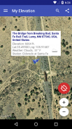
●แอปพลิเคชั่นแสดงระดับผิว
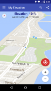
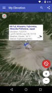
ระดับความสูง
เหนือระดับน้ำทะเลโดยใช้ละติจูดและลองจิจูด มันไม่ได้ให้
ระดับความสูง
ในกรณีที่คุณอยู่ในเครื่องบินสูงในอาคารหรือสูงจากพื้นด้วยเหตุผลบางอย่าง
●แอปพลิเคชันนี้ ต้องมีการเชื่อมต่อข้อมูลที่ใช้งานได้ เพื่อให้สามารถแสดงตำแหน่งของคุณบนแผนที่รับระดับความสูงที่แม่นยำและให้เนื้อหาที่หลากหลายเพิ่มเติม มันไม่มีโหมดออฟไลน์ โปรดพิจารณาเรื่องนี้ก่อนที่จะให้คะแนนไม่ดีเมื่อไม่ได้ทำงานเมื่อคุณไม่มีการเชื่อมต่อข้อมูล
รายการคุณสมบัติ
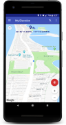
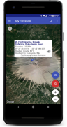
●โหมดตามฉัน - ติดตามตำแหน่งปัจจุบันของคุณตามเวลาจริง ดูการเคลื่อนไหวของคุณบนแผนที่และดูการยกระดับและพิกัดของคุณในขณะที่คุณเคลื่อนที่
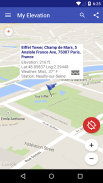
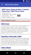
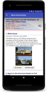
●ค้นหาสถานที่และดูแผนที่บินตรงไปยังสถานที่เหล่านั้น ระดับความสูงของฉันจะบอกสภาพอากาศที่นั่นและให้คุณเรียกดูบทความ Wikipedia เกี่ยวกับสถานที่น่าสนใจในบริเวณใกล้เคียง หากคุณสงสัยเกี่ยวกับสถานที่อื่นคุณจะรักสิ่งนี้!
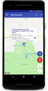
●กดตำแหน่งบนแผนที่ค้างไว้และระดับความสูงของฉันจะบอกสภาพอากาศที่นั่นและให้คุณเรียกดูบทความ Wikipedia เกี่ยวกับสถานที่น่าสนใจใกล้เคียง
●เพิ่มบุ๊คมาร์คสำหรับสถานที่ที่คุณต้องการจดจำ
●แบ่งปันตำแหน่งของคุณหรือสิ่งที่คุณค้นหาในการค้นหากับเพื่อนของคุณในข้อความหรืออีเมล
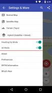
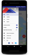
ตัวเลือกการแสดงผล
โหมดแผนที่ - ให้คุณเลือกหนึ่งในสี่ประเภทแผนที่ Google (ปกติ, ดาวเทียม, โทโปและไฮบริด)
หัวเรื่อง Up, Map Tilt และ Night Mode
ลองและแจ้งให้เราทราบว่ามันไปอย่างไร
ส่งอีเมลถึงเราที่ rdhsoftware@gmail.com
หรือเยี่ยมชม https://www.facebook.com/MyElevation
แอปพลิเคชันนี้ใช้ Google Analytics เพื่อรวบรวมข้อมูลที่ไม่ระบุตัวตนเกี่ยวกับวิธีการใช้แอปพลิเคชันและความล้มเหลวที่เกิดขึ้น สิ่งนี้ทำให้เราสามารถทำให้แอปพลิเคชันดีขึ้นในการเปิดตัวแต่ละครั้ง คุณสามารถยกเลิกได้โดยยกเลิกการตรวจสอบรายการข้อมูล Analytics ในการตั้งค่าแอปพลิเคชัน ไม่มีการรวบรวมข้อมูลส่วนบุคคล
My Elevation--เวอร์ชั่น1.79
(20-01-2025)My Elevation - ข้อมูล APK
เวอร์ชั่น APK: 1.79แพ็คเกจ: com.rdh.mulligan.myelevationเวอร์ชั่นล่าสุดของMy Elevation
เวอร์ชั่นอื่น


แอปในประเภทเดียวกัน


